
powered by
- Florida CPA |
- Datasets |
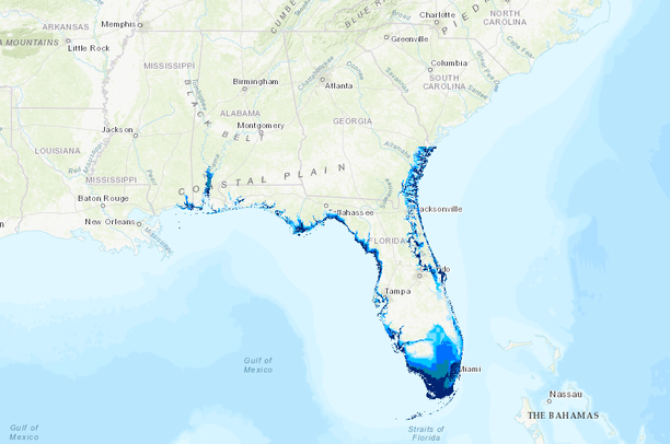
- Florida Sea Level Rise Projections in Meters
Florida Sea Level Rise Projections in Meters
Dec 10, 2015
(Last modified Dec 22, 2023)
- Description:
- Sea level rise projections produced by the University of Florida Geoplan Center. These projections measure sea level rise in meter increments up until 6 meters, the predicted sea level rise measure if both Greenland and the West Antarctic ice sheet melt.
- Data Provided By:
- University of Florida Geoplan Center
- Data Hosted by:
- ScienceBase (USGS) View Record
- Map Service URL:
- https://www.sciencebase.gov/arcgis/rest/services/Catalog/564c8ab3e4b0ebfbef0d34b8/MapServer
- Content date:
- 2015 (Date Received)
- Citation:
- University of Florida Geoplan Center
- Contact Organization:
- Peninsular Florida LCC
- Contact Person(s):
- not specified
- Use Constraints:
- SLR data are intended for landscape scale planning and informational purposes. Note: Data layers are in a Web Mercator projection and are optimized for web viewing, not analysis. Please download the source data for analysis purposes.
- Layer:
- Layer Type:
- Currently Visible Layer:
- All Layer Options:
- Layers in this dataset are based on combinations of the following options. You may choose from these options to select a specific layer on the map page.
- Description:
- Spatial Resolution:
- Credits:
- Citation:
- Purpose:
- Methods:
- References:
- Other Information:
- Time Period:
- Layer Accuracy:
- Attribute Accuracy:
FGDC Standard Metadata XML
Click here to see the full FGDC XML file that was created in Data Basin for this layer.
Original Metadata XML
Click here to see the full XML file that was originally uploaded with this layer.
This dataset is visible to everyone
- Dataset Type:
-
External Map Service (ArcGIS)
Bookmarked by
5 Members
,
3 Groups
Included in
14 Public Maps
,
15 Private Maps
Included in
4 Public Galleries
[{"url": "https://www.sciencebase.gov/catalog/file/get/564c8ab3e4b0ebfbef0d34b8", "title": "Download All Attached Files from ScienceBase"}]
About the Uploader
Peninsular Florida Landscape Conservation Cooperative
GIS Staff with PFLCC
The Peninsular Florida Landscape Conservation Cooperative (PFLCC) is part of a national network of Landscape Conservation Cooperatives(LCCs). LCCs are applied conservation science partnerships among federal agencies, regional organizations, states, tribes, NGOs, private stakeholders, universities...